
Overview
The demand for transportation services is directly related to an area’s demographic, economic, and geographic characteristics. This chapter examines socioeconomic forecasts and their effects on the transportation system in the Pikes Peak Region.
Expanding population, employment, and urban area size, along with improved economic conditions, result in an increased need for transportation facilities and services. These include freight, roadway, transit, bicycle, and pedestrian facilities, along with strategies intended to increase the efficient use of existing facilities.
By 2050, the region is projected to be home to over 1,023,000 people, growing by more than 268,000 from 2020. The State Demographer also forecasts the number of new jobs to grow by over 95,000 from 2020 to 2050. The number of occupied housing units is expected to be 400,923 in 2050 up from 283,470 in 2020. Figure 39 shows the population, job and housing unit growth anticipated from 2020-2050.
Figure 39: Population, Job, and Housing Unit Growth 2020-2050
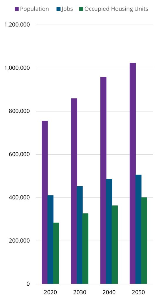
More people and jobs mean more trips for work, shopping, health, and recreation. These trips will increase the demand on an already strained transportation network.
Proactive regional planning may be able to mitigate the potential issues on the regional transportation system. PPACG uses forecasts from the Colorado State Demography Office to develop the area’s socioeconomic trends. This assessment includes an estimation of future residential and commercial growth based on zoning and development entitlements, projecting where people might live and work so that transportation investments will address anticipated issues.
Transportation Analysis Zones
To project future transportation needs and confirm that the 2050 Long Range Transportation Plan is consistent with anticipated growth patterns, PPACG analyzed regional projections of population and employment and allocated them into small sub-areas of the region, referred to as transportation analysis zones (TAZs). There are 934 TAZs in the Colorado Springs Metropolitan Statistical Area (MSA), which includes all of El Paso and Teller Counties.
Each TAZ boundary is typically derived from Census Block Groups and then edited to be coincident with parcel boundaries and either split or merged to best represent homogeneous residential, commercial, or military areas. Figure X shows the TAZs in the region by the ration of residential to commercial areas.
Figure 40: 2020 Ratio Residential/Commercial Areas by TAZ
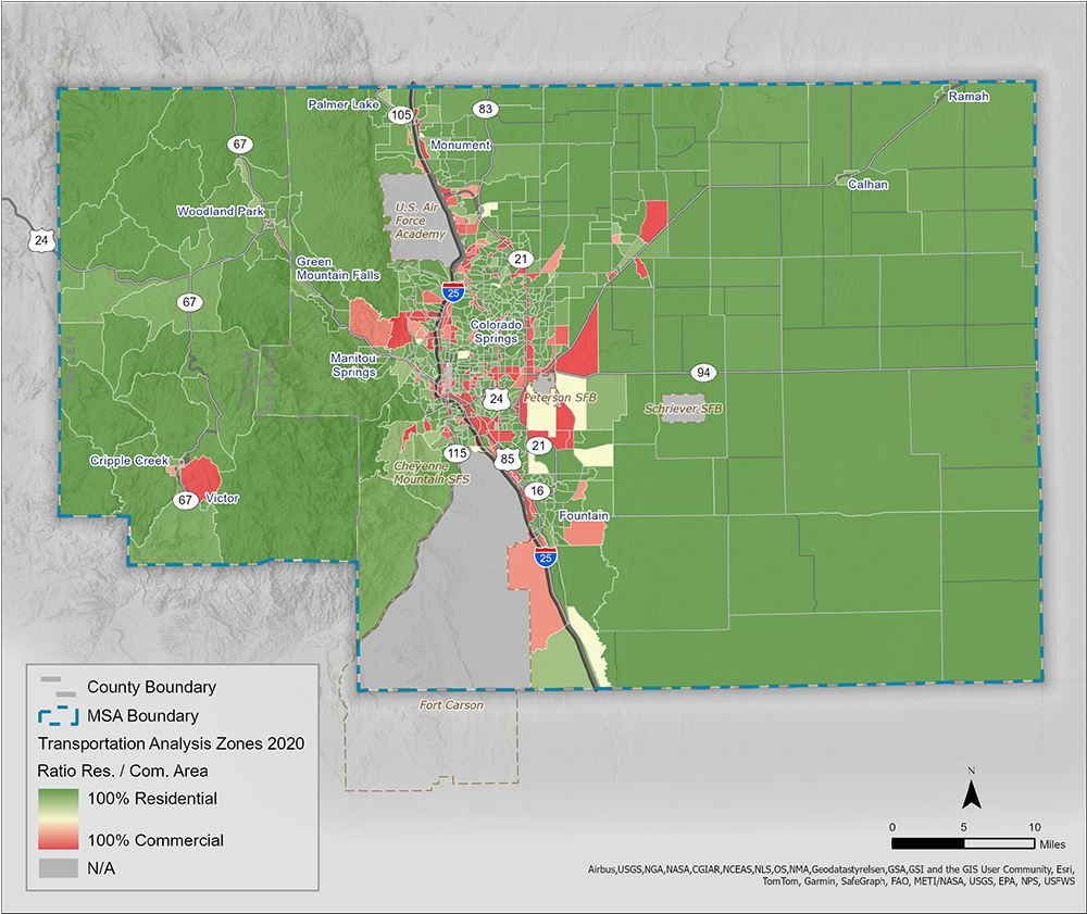
Transportation trips are calculated in the Travel Demand Model (TDM) to and from TAZs.
Methodology
Many types of socioeconomic models exist. The methodology used for this plan was a collaborative process involving local land-use planners, economic development staff, transportation planners, and other local organizations.
The Colorado State Demographer develops an annual forecast for population and employment growth for each county in Colorado. The population and employment forecasts for El Paso and Teller Counties are combined to develop regional control totals for PPACG’s demographic forecast.
The model incorporates both the population and employment control totals and ensures that the model’s projections meet but do not exceed expected growth. Per the demographer’s forecasts, the Colorado Springs MSA is expected to have 505,936 jobs and 1,023,342 people by 2050.
Because each jurisdiction within the Pikes Peak Region has its own development plans, PPACG’s method was to use a best-fit scenario for where household and employment development and growth might occur. Growth was distributed within natural and regulatory constraints. Housing growth was limited in each TAZ to not exceed typical build rates in the area. Peak build rates are around 195 housing units (HU)/year in fast growing developments like Wolf Ranch in northeast Colorado Springs. Build rates are typically much lower in more rural locations.
PPACG took current growth patterns and development plans into account and assigned growth based on these inputs. It is important to note that the growth that was assigned is a snapshot in time, based on plans and information that were available at the time of the land use modeling.
Areas that are not developable or relatively difficult to develop, due to ownership or natural hazards, were also accounted
for in the model. Constraints included floodplains, steep slopes, and military influence areas, as well as land owned by the State Land Board, National Park Service, U.S. Forest Service, and others.
After development was allocated, PPACG held meetings with local planners and organizations to ensure support for the growth distributions. PPACG’s growth forecast expects 505,629 jobs and 1,023,259 people by 2050, while not exceeding
the control totals from the Colorado Department of Local Affairs (DOLA). The population control totals are compared with the PPACG projected totals in Table 3.
Table 2: Population Control Totals vs. PPACG Population Totals
| Year | DOLA Control Population | PPACG Population |
|---|---|---|
| 2020 | 757,111 | 755,105 |
| 2030 | 859,427 | 858,962 |
| 2040 | 958,942 | 958,237 |
| 2050 | 1,023,342 | 1,023,259 |
DOLA Control Pop. Source: “State and Region,” “Total Population Lookup” State Demography Office, Colorado Department of Local Affairs.
The socioeconomic data is developed in 10-year intervals to align with banding of projects to be modeled. These 10-year bands are needed so that projects can be built when sufficient funding is available.
The proposed projects, along with the land use forecasts, are modeled for travel time and the State of Colorado required GHG performance.
While the long range plan is a 25-year outlook, PPACG uses 2020 as a base year for the 2050 LRTP. The 2020 Census Data was the last collection of data by the United States Census Bureau. By using the 2020 data as a base year, it provides a more realistic look at the socioeconomic data to better forecast the future 10-year bands.
Transportation and Land Use
Land use and transportation planning are inextricably linked. Low-density development patterns may make it difficult to use transportation methods such a walking, bicycling, transit, or rideshares for normal daily activities. For example, new residential developments that are removed from activity centers, are highly auto-dependent, and use a curvilinear street pattern make it both physically and financially difficult to provide effective transit services.
Developments that take transit operations into account during design and construction encourage increased transit use and make transit operations more efficient.
Compatible land uses and increasing density complements and supports efficient transit, in addition to an overall reduction in automobile reliance. Likewise high-density and well-connected development and compatible land uses make mode choices like bicycling or walking more attractive.
Pursuing development that increases density can also decrease vehicle miles traveled, since compact development patterns shorten trip distances. In turn, land use can benefit the community as a whole by supporting transportation choices, contributing to lowering traffic congestion, decreasing air pollution, and making more efficient use of infrastructure.
Land use policies and changes are directed by individual jurisdictions, and PPACG does not have authority over land use. However, the State has passed legislation in recent years aimed at encouraging land use change to increase residential density and promote transit.
Land Use Forecast
The land use model provides current and forecasted data pertaining to land use, demographics, and socioeconomic factors within El Paso and Teller counties, which are used as critical inputs to the PPACG TDM for modeling current and future traffic conditions. Land use and travel demand modeling are incorporated into PPACG’s planning process, both directly and indirectly, for activities such as congestion forecasting, equity analysis, and performance comparisons.
Population
As Colorado’s population increases, Colorado Springs is forecasted to become the largest city in the state by 2050, growing by over 268,000 from 2020.
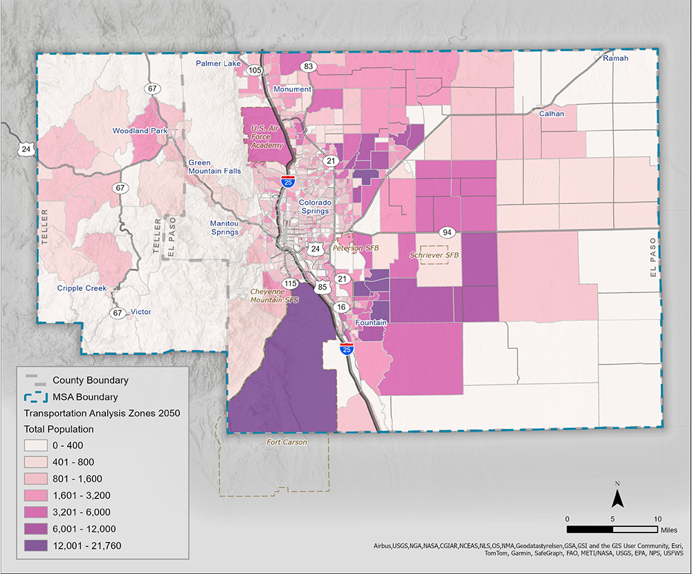
Figure X shows the TAZs by forecasted population change from 2020-2050. The areas of greatest growth occur mainly east of Powers Boulevard in Colorado Springs and around the City of Fountain. Development in North and South Banning Lewis Ranch is expected to see rapid growth. This map also depicts an increase in development around Peterson SFB. It should be noted that low growth does
not mean low population. Rather, Figure X shows the forecasted total population by TAZ in 2050. By 2050, the TAZs that contain Fort Carson, North Banning Lewis Ranch, and the area south of Peterson SFB and east of Fountain are among the most populated.
Figure 42: 2020-2050 Population Changes by TAZ
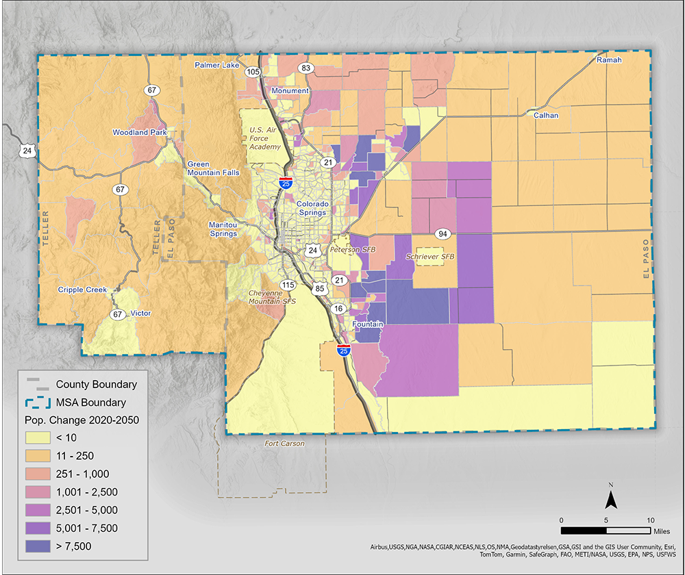
Figure 43: 2050 Total Population by TAZ
Age Brackets
Figure X depicts the net migration by age from 2010-2020. Growth patterns slowed significantly during the Covid pandemic. Though the rates of population and job growth have been declining compared to those prior to 2020, there is still an influx of people and jobs coming into the area. The largest group of people in-migrating to the Pikes Peak Region are those in the 25-35 age bracket. The region attracts this age group likely because of the large military presence, universities, and early career opportunities in the region. It is also an attractive area for young families.
Figure 44: Net Migration by Age 2010-2020

There was a large boom of in-migration in the early 1990s of people in the 25-35 age range. Much of that population is now aging in place. For this reason, the largest share of growth in the region presently is among those age 65 and above. Figures X depicts the population by age bracket for 2020, 2030, 2040, and 2050.
Figure 45: Age Brackets 2020-2050

Residential Units/Housing
The majority of TAZs throughout the region have seen major growth in residential units in the past decade. Single-family housing is and will continue to make up the majority of housing units in the Pikes Peak Region. There were 200,632 single-family dwellings in 2020 but by 2050 there are expected to be 275,795 single-family dwellings.
Meanwhile there were 93,785 multi-family units in the MSA in 2021. By 2050 there are expected to be 139,371 multi-family units. In this case, multi-family refers to units includes condos, duplexes, apartments, senior living facilities, subsidized housing, military housing, and accessory dwelling units. However, college dorms, jails, juvenile facilities, and barracks are not included in the multi-family numbers.
Table X shows the projected number of single- and multi-family housing units for 2020, 2030, 2040, and 2050.
Table 3: Housing Projections
| Year | Single Family Units | Multi-Family Units |
|---|---|---|
| 2020 | 200,632 | 93,785 |
| 2030 | 222,545 | 113,387 |
| 2040 | 247,990 | 126,852 |
| 2050 | 275,795 | 139,371 |
Figure 46 depicts new home construction 2011-2023. The largest areas of recent growth in residential units is seen in northeastern Colorado Springs, west of downtown Colorado Springs, Woodland Park, and western Teller County. This map includes single-family and multi-family units such as duplexes or townhomes that are purchased by the resident. It does not include apartments or other facilities that are being rented by resident.
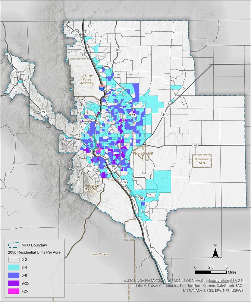
Figure 47 depicts the number of residential units per acre projected for 2050. Housing density currently varies widely across the Pikes Peak Region. For the 2050 estimates, housing density is highest in a few TAZs located in downtown Colorado Springs. Other high density areas are mostly located along the Academy Boulevard corridor in Colorado Springs, where there is a high percentage of multi-family units. Housing density decreases farther from urban centers like Colorado Springs, Fountain, and Monument. In 2050 it is estimated that the average density will be about 2.72 housing units per acre in the MSA, up from 2.23 in 2020.
Housing Affordability
Housing affordability in the Pikes Peak Region is low due to high housing prices, rising interest rates, and a housing deficit. As of February 2024, the average price of a home in Colorado Springs had increased 119% from 2015 to $449,123, while mortgage and interest rates have increased 82.6% over the same period. In the fourth quarter of 2023, the average apartment rent was $1,456 per month.
There are several initiatives in the region aimed at improving housing affordability, access, and production. The region should strive to support land use decisions and projects that provide a variety of housing types and sizes, serving a range of demographic sectors, and meet the needs of residents and families through various life stages and income levels. For example, working families may need larger apartments near schools, employment, and transit, or low-income seniors may want housing with age-in-place features and outdoor access.
Figure 46: New Home Construction 2011-2023
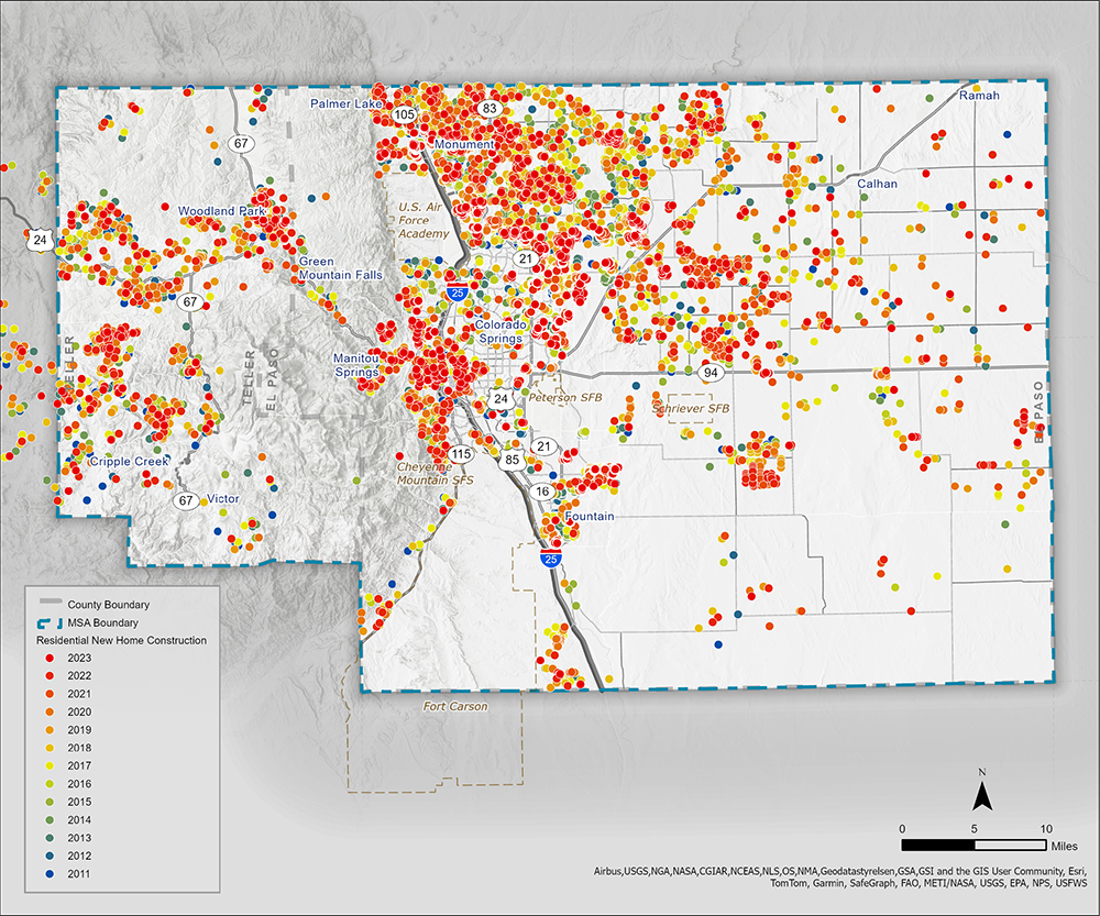
Figure 47: Residential Units per Acre 2050
Jobs
It is anticipated that, like the population, jobs will grow in the region, including new businesses moving in. Figure 48 shows employment by sector for 2020, 2030, 2040, and 2050. The overall number of jobs is anticipated to increase 23%, from around 412,000 in 2020 to more than 507,000 in 2050. In 2020, service employees accounted for about 37% of jobs, followed by office
(29%), labor (13%), retail (11%), and active duty military (9%).
Figure 48: Employment by Sector

Figure 49 depicts the anticipated job changes by TAZ from 2020-2050. The largest increase in jobs is anticipated along the Powers Boulevard corridor, with a significant amount of the employment along this corridor being labor to support new development taking place.
Figure 49: 2020-2050 Total Job Changes by TAZ
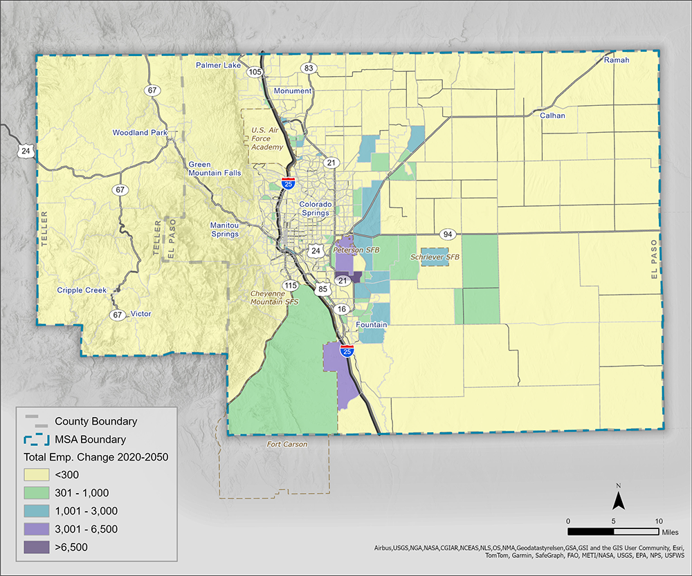
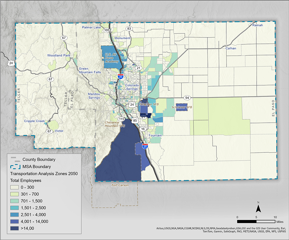
Figure 50 depicts the number of jobs by TAZ anticipated in 2050. The TAZs with the largest number of jobs are projected to be the military installations along with a new employment center called Peak Innovation Park. This is located near the Amazon distribution center just south of the Colorado Springs Municipal Airport. This employment center could bring over 30,000 jobs at full build-out.
Figure 50: 2050 Total Jobs by TAZ
The Southern Colorado Rail Park, as discussed in Chapter 4, is also projected to be a catalyst for commercial development and job creation. It is expected to create around 5,000 jobs.
Areas with high residential growth are also projected to see large commercial centers. An example of this is Polaris Pointe in northern Colorado Springs, near I-25 and North Gate Boulevard where the new music venue, restaurants, and shopping are expected to create a hub of commercial activity in that area.