
Map title
Soil Classification Data
Text on map
Soil Classification Data
Job No: 161921
FIG No. 13-16
Date: 4/2/18
Rocky Mountain Group
Architectural, Structural, Forensics, Geotechnical, Materials Testing, Civil Planning
Colorado Springs: (Corporate Office)
2910 Austin Bluffs Parkway
Colorado Springs, CO 80918
(719) 548-0600
SOUTHERN COLORADO, DENVER METRO, NORTHERN COLORADO
Soil Classification for Test Bores C-1 to C-5

Alternative Text for Map Frame/Map Description
Soil classification data for River Bend Crossing test soil bores C-1 through C-5
Text Version
The soil classification data provides information on the soil test bores C-1 through C-5 at the River Bend Crossing site. The top half includes a line chart with the five test bores, showing data for three sets of data points:
- Top axis: U.S. sieve opening in inches, ranging from 3 to 3/8; U.S. sieve numbers ranging from 10 to 200; and hydrometer, with no range indicated
- Left axis: Percent passing by weight, ranging from 0 to 100
- Bottom axis: Grand size in millimeters, ranging from 100 to 0.001, and the following labels running along the same axis:
- Cobbles
- Gravel – Coarse
- Gravel – Fine
- Sand – Coarse
- Sand – Medium
- Sand – Fin
- Silt or clay
The lines run from top left to the bottom right, largely in alignment, from a grain size of 20 millimeters to 0.1, percent from 100 to 0 to 15, and U.S. sieve opening in inches from 1 to 12 to a U.S. sieve number of 200
| Test boring | Depth (ft) | Classification | LL | PL | PI |
|---|---|---|---|---|---|
| C01 | 9.0 | Well-graded sand with gravel (SW) | NP | NP | NP |
| C02 | 14.0 | Well-graded sand with silt and gravel (SW-SM) | NP | NP | NP |
| C03 | 4.0 | Silty sand with gravel (SM) | NP | NP | NP |
| C04 | 9.0 | Well-graded sand with silty and gravel (SW-SM) | NP | NP | NP |
| C05 | 14.0 | Well-graded sand with gravel | NP | NP | NP |
| Test boring | Depth (ft) | %Gravel | %Sand | %Silt and %Clay |
|---|---|---|---|---|
| C01 | 9.0 | 44.7 | 51.9 | 3.4 |
| C02 | 14.0 | 21.3 | 71.6 | 7.1 |
| C03 | 4.0 | 20.5 | 64.4 | 15.1 |
| C04 | 9.0 | 22.7 | 70.3 | 7.0 |
| C05 | 14.0 | 28.3 | 68.4 | 3.3 |
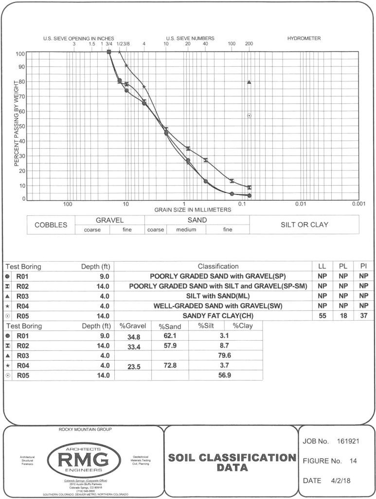
Soil Classification for Test Bores R-1 to R-5
Alternative Text for Map Frame/Map Description
Soil classification data for River Bend Crossing test soil bores R-1 to R-5
Text Version
The soil classification data provides information on the soil test bores R-1 through R-5 at the River Bend Crossing site. The top half includes a line chart with the five test bores, showing data for three sets of data points:
- Top axis: U.S. sieve opening in inches, ranging from 3 to 3/8; U.S. sieve numbers ranging from 10 to 200; and hydrometer, with no range indicated
- Left axis: Percent passing by weight, ranging from 0 to 100
- Bottom axis: Grand size in millimeters, ranging from 100 to 0.001, and the following labels running along the same axis:
- Cobbles
- Gravel – Coarse
- Gravel – Fine
- Sand – Coarse
- Sand – Medium
- Sand – Fin
- Silt or clay
The lines for R-1, R-2 and R-4 run from top left to the bottom right, largely in alignment, from a grain size of 20 millimeters to 0.1, percent from 100 to 0, and U.S. sieve opening in inches from 3/4 to 1/2 to a U.S. sieve number of 200. R-3 is represented by a single point at the intersection of 0.1 grain size, 80 percent passing by weight and 200 U.S. sieve number. For R-5, it is a single point at the intersection of 0.1 grain size, 55 percent passing by weight and 200 U.S. sieve number.
| Test boring | Depth (ft) | Classification | LL | PL | PI |
|---|---|---|---|---|---|
| R01 | 9.0 | Poorly graded sand with gravel (SP) | NP | NP | NP |
| R02 | 14.0 | Poorly graded sand with silt and gravel (SP-SM) | NP | NP | NP |
| R03 | 4.0 | Silt with sand (ML) | NP | NP | NP |
| R04 | 4.0 | Well-graded sand with gravel (SW) | NP | NP | NP |
| R05 | 14.0 | Sandy fat clay (CH) | 55 | 18 | 37 |
| Test boring | Depth (ft) | %Gravel | %Sand | %Silt and %Clay |
|---|---|---|---|---|
| R01 | 9.0 | 34.8 | 62.1 | 3.1 |
| R02 | 14.0 | 33.4 | 57.9 | 8.7 |
| R03 | 4.0 | 79.6 | ||
| R04 | 4.0 | 23.5 | 72.8 | 3.7 |
| R05 | 14.0 | 56.9 |
Soil Classification for Test Bores R-6 to R-10

Alternative Text for Map Frame/Map Description
Soil classification data for River Bend Crossing test soil bores R-6 to R-10
Text Version
The soil classification data provides information on the soil test bores R-6 through R-10 at the River Bend Crossing site. The top half includes a line chart with the five test bores, showing data for three sets of data points:
- Top axis: U.S. sieve opening in inches, ranging from 3 to 3/8; U.S. sieve numbers ranging from 10 to 200; and hydrometer, with no range indicated
- Left axis: Percent passing by weight, ranging from 0 to 100
- Bottom axis: Grand size in millimeters, ranging from 100 to 0.001, and the following labels running along the same axis:
- Cobbles
- Gravel – Coarse
- Gravel – Fine
- Sand – Coarse
- Sand – Medium
- Sand – Fin
- Silt or clay
The lines for R-7 and R-9 run from top left to the bottom right. For R-7, it runs from a grain size of 25 millimeters to 0.1, percent from 100 to 5, and U.S. sieve opening in inches from 1 to a U.S. sieve number of 200. For R-9, it runs from a grain size of 15 millimeters to 0.1, percent from 100 to 5, and U.S. sieve opening in inches from 1/2 to a U.S. sieve number of 200. The other three test soil bores, R-6, R-9 and R-10, are all represented by a single point at the intersection of .01, percent from 85 to 90, and a U.S. sieve number of 200.
| Test boring | Depth (ft) | Classification | LL | PL | PI |
|---|---|---|---|---|---|
| R06 | 14.0 | Fat clay (CH) | 53 | 20 | 33 |
| R07 | 9.0 | Poorly graded gravel with sand (GP) | NP | NP | NP |
| R08 | 9.0 | Fat clay (CH) | 53 | 24 | 29 |
| R09 | 14.0 | Well-graded sand with silt and gravel (SW-SM) | NP | NP | NP |
| R10 | 9.0 | Lean clay (CL) | 43 | 13 | 30 |
| Test boring | Depth (ft) | %Gravel | %Sand | %Silt and %Clay |
|---|---|---|---|---|
| R06 | 14.0 | 88.5 | ||
| R07 | 9.0 | 48.9 | 47.2 | 3.9 |
| R08 | 9.0 | 91.6 | ||
| R09 | 14.0 | 20.4 | 73.9 | 5.7 |
| R10 | 9.0 | 85.6 |
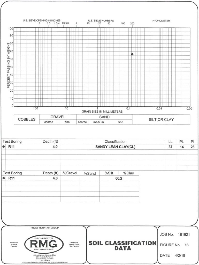
Soil Classification for Test Bores R-11
Alternative Text for Map Frame/Map Description
Soil classification data for River Bend Crossing test soil bores R-11
Text Version
The soil classification data provides information on the soil test bores R-11 at the River Bend Crossing site. The top half includes a chart with the test bore, showing data for three sets of data points:
- Top axis: U.S. sieve opening in inches, ranging from 3 to 3/8; U.S. sieve numbers ranging from 10 to 200; and hydrometer, with no range indicated
- Left axis: Percent passing by weight, ranging from 0 to 100
- Bottom axis: Grand size in millimeters, ranging from 100 to 0.001, and the following labels running along the same axis:
- Cobbles
- Gravel – Coarse
- Gravel – Fine
- Sand – Coarse
- Sand – Medium
- Sand – Fin
- Silt or clay
R-11 is represented by a single point, at the intersection of grain size of 0.8 millimeters, percent of 65 and a U.S. sieve number of 200.
| Test boring | Depth (ft) | Classification | LL | PL | PI |
|---|---|---|---|---|---|
| R11 | 4.0 | Sandy lean clay (CL) | 37 | 14 | 23 |
| Test boring | Depth (ft) | %Gravel | %Sand | %Silt and %Clay |
|---|---|---|---|---|
| R11 | 4.0 | 66.2 |