
Map title
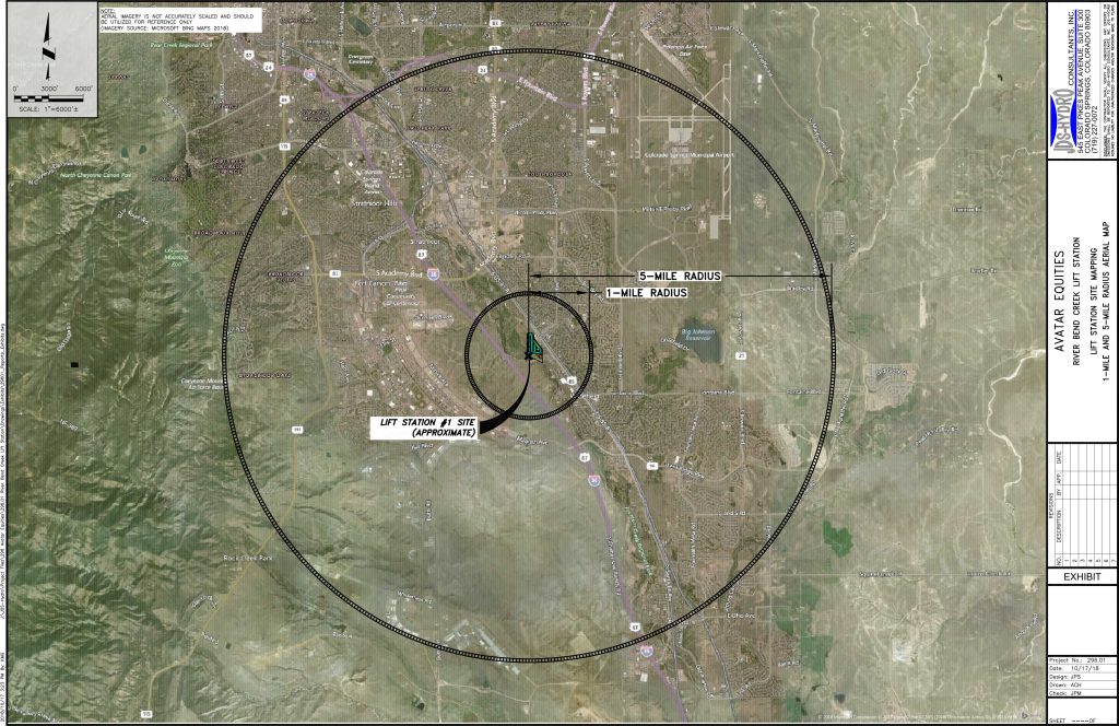
River Bend Creek Lift Station – Lift Station Site Mapping – 1-Mile and 5-Mile Radius Aerial Map
Text on map
Avatar Equities
River Bend Creek Lift Station
Lift Station Site Mapping
1-Mile and 5-Miole Radius Aerial Map
JDS-Hydro Consultants, Inc.
545 East Pikes Peak Avenue, Suite 300
Colorado Springs, Colorado 80903
(719) 227-0072
Disclaimer: The contractor shall verify all dimensions. Any errors or omissions shall be reported to JDS-Hydro Consultants, Inc. JDS-Hydro assumes no liability for unauthorized changes and/or revisions to the plans.
Note: Aerial imagery is not accurately scaled and should be utilized for reference only. (Imagery Source: Microsoft Bing Maps 2018)
Project No: 296.01
Date: 10/17/18
Design: JPS
Drawn: ACH
Check: JPM
Map labels:
- Lift Station #1 Site (approximate) with an arrow pointing to the site location
- 1-Mile Radius
- 5- Mile Radius
Alternative Text for Map Frame/Map Description
An aerial map showing a one-mile radius circle and a five-mile radius circle surrounding the proposed River Bend Creek Lift Station on the west side of the intersection of Main Street and U.S. Highway 85/87 in Security, Colorado.
Text Version
An aerial map showing a one-mile radius circle and a five-mile radius circle surrounding the proposed River Bend Creek Lift Station on the west side of the intersection of Main Street and U.S. Highway 85/87 in Security, Colorado.
Within the one-mile radius is:
- Downtown or central business district of Security, Colorado
- Portion of Interstate 25 and Fountain Creek
Within the five-mile radius is:
- The central housing and training area of Fort Carson
- The terminal of the Colorado Springs Airport
- The city of Fountain, Colorado northwest of Jimmy Camp Creek and Ohio Avenue
- Big Johnson Reservoir
- The City of Colorado Springs in an arc extending from Cheyenne Mountain Space Force Station; the intersection of Colorado Highway 115 and Lake Avenue; the interchange of Interstate 25 and Martin Luther King, Jr., Bypass; the terminal of the Colorado Springs Airport; and the intersection of Bradley Road and Marksheffel Road.