
Title
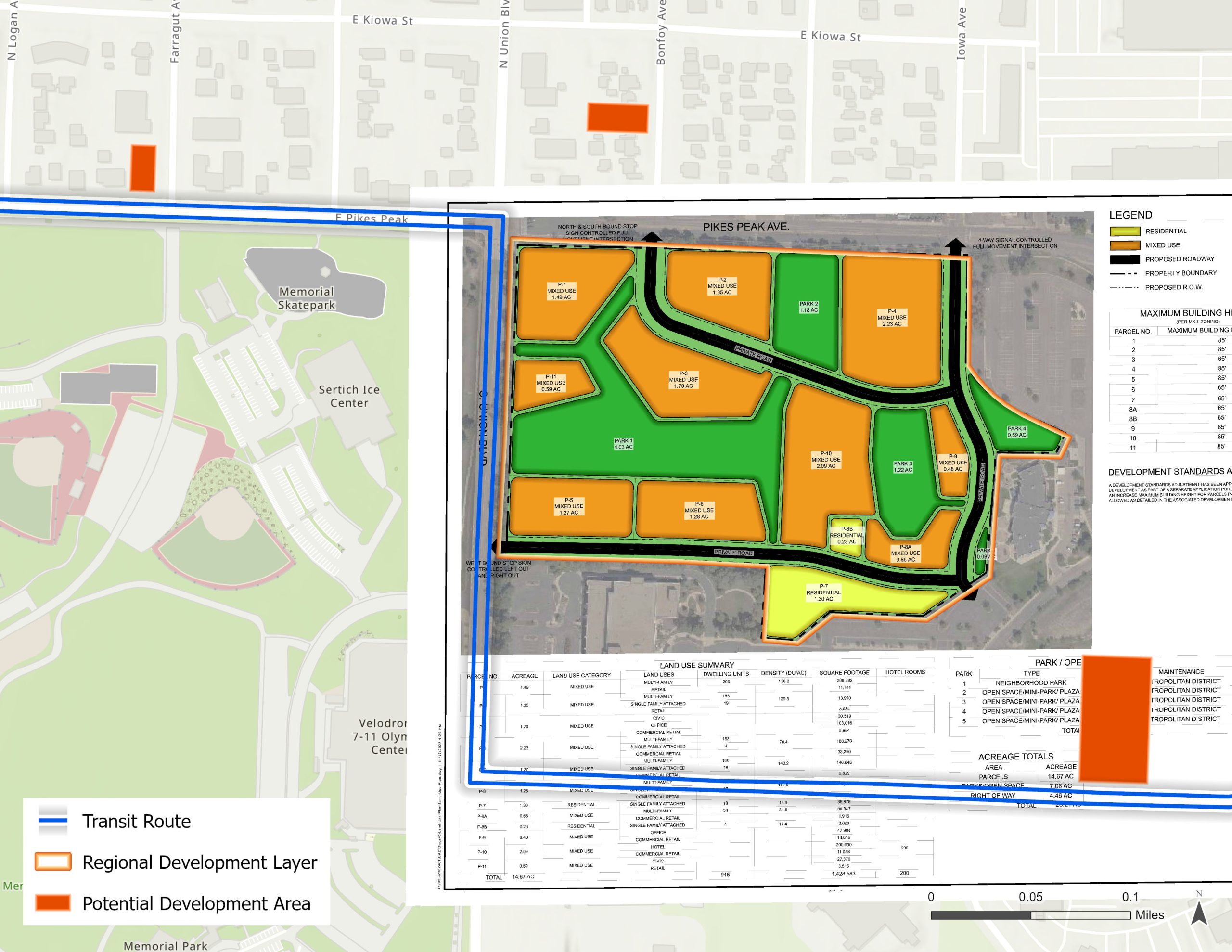
A detailed map of the Printers Hill development plan showing housing unit densities, commercial area, and neighboring parks, transit, and other development areas that are all used to forecast changes in population, employment, and trip generation in this area
Text on Map
Legend
- Yellow shading: Residenial
- Orange shading: Mixed Used
- Black shading: Proposed roadway
- Dashed thick black line: Property Boundary
- Dashed thin black line: Proposed Right of Way
- Blue line: Transit Route
- Orange border: Regional Development Layer
- Red shading: Potential Development Area
Land Use Summary
| Parcel Number | Acreage | Land Use Category | Land Uses | Dwelling Units | Density (DU/AC) | Square Footage | Hotel Rooms |
|---|---|---|---|---|---|---|---|
| P-1 | 1.49 | Mixed Use | Multi-Family | 206 | 136.2 | 308,282 | |
| Retail | 11,741 | ||||||
| P-2 | 1.35 | Mixed Use | Multi-Family | 156 | 129.3 | 13,990 | |
| Single Family Attached | 19 | ||||||
| Retail | 3,084 | ||||||
| P-3 | 1.70 | Mixed Use | Civic | 30,519 | |||
| Office | 103,016 | ||||||
| Commercial Retail | 5,984 | ||||||
| P-4 | 2.23 | Mixed Use | Multi-Family | 153 | 70.4 | 188,270 | |
| Single Family Attached | 4 | ||||||
| Commercial Retail | 32,290 | ||||||
| P-5 | 1.27 | Mixed Use | Multi-Family | 160 | 140.2 | 146,646 | |
| Single Family Attached | 18 | ||||||
| Commercial Retail | 2,829 | ||||||
| P-6 | 1.28 | Mixed Use | Multi-Family | Covered by blue transit line graphic | 119.5 | Covered by blue transit line graphic | |
| Single Family Attached | Covered by blue transit line graphic | ||||||
| Commercial Retail | Covered by blue transit line graphic | ||||||
| P-7 | 1.30 | Residential | Single Family Attached | 18 | 13.9 | 36,678 | |
| P-8A | 0.66 | Mixed Use | Multi-Family | 54 | 81.8 | 80,847 | |
| Commercial Retail | 1,916 | ||||||
| P-8B | 0.23 | Residential | Single Family Attached | 4 | 17.4 | 8,629 | |
| P-9 | 0.48 | Mixed Use | Office | 47,904 | |||
| Commercial Retail | 13,616 | ||||||
| P-10 | 2.09 | Mixed Use | Hotel | 200,000 | 200 | ||
| Commercial Retail | 11,038 | ||||||
| P-11 | 0.59 | Mixed Use | Civic | 27,370 | |||
| Retail | 3,515 | ||||||
| TOTAL | 14.67 AC | 945 | 1,428,583 | 200 |
Acreage Totals
| Area | Acreage |
|---|---|
| Parcels | 14.67 AC |
| Parks / Open Space | 7.08 AC |
| Right of Way | 4.46 AC |
| TOTAL | 26.21 AC |
Park / Ope (remainder of line covered by Potential Development Area block)
| Park | Type | Area covered by Potential Development Area block | Maintenance |
|---|---|---|---|
| 1 | Neighborhood Park | Area covered by Potential Development Area block | tropolitan district |
| 2 | Open Space / Mini-Park / Plaza | Area covered by Potential Development Area block | tropolitan district |
| 3 | Potential Development Area | Area covered by Potential Development Area block | tropolitan district |
| 4 | Potential Development Area | Area covered by Potential Development Area block | tropolitan district |
| 5 | Potential Development Area | Area covered by Potential Development Area block | tropolitan district |
| TOTAL | Area covered by Potential Development Area block |
Alternate Text for Map Description
A detailed map of the Printers Hill development plan showing housing unit densities, commercial area, and neighboring parks, transit, and other development areas that are all used to forecast changes in population, employment, and trip generation in this area
Text Version of Map
The map shows the development plan for the Printers Hill development on the southeast corner of Pikes Peak Avenue and Union Boulevard. The parcels indicated are arranged in the map with
- P-1 in the top left corner
- P-2 directly to the east, across a private road
- P-3 directly to the south of P-2, across a private road and on the same side of the road as P-1. It is separated from P-1 by a small portion of Park 1.
- Park 2 is directly to the east of P-2
- P-4 is directly to the east of Park 2, and is bordered on the east that is a private road that marks the eastern edge of the development boundary
- P-11 is south of P-1 and west of P-3, separated from those two parcels by small portion of Park 1
- Park 1 is roughly south of P-11 and P-3, west of P-10, and north of P-5 and P-6
- P-5 is on the southwest corner of the development plan
- P-6 is directly east of P-5.
- P-10 is east of Park 1, P-3 and P-6. There are small segments of Park 1 that separate P-10 from P-3 and P-6
- P-8B makes up the southeast portion of P-10
- Park 3 is west of P-10
- P-8A is south of Park 3, and east of P-8B
- P-9 is east of Park 3, with a small portion of Park 3 that separates P-9 from P-8A
- Park 4 is east of P-9, across a private road that otherwise would be the east boundary of the development plan
- P-7 is south of P-10, P-8B and P-8A, across a private road that otherwise makes up the south boundary of the development plan
Blue lines indicate transit routes, running in a line the western portion of the map along Pikes Peak, south along Union Boulevard, and east along Parkside Drive.
Three red blocks indicate potential development areas outside of the Printers Hill development plan:
- Southeast corner of Pikes Peak Avenue and Farragut Avenue
- 20 Bonfoy Aveue
- An area roughly bounded by Kidskare Point, Printers Parkway and Parkside Drive.